New Seoul Subway Map Design in 2023
The city of Seoul has unveiled its new “Seoul Subway Map Design,” which was created in consultation with experts in the fields of vision, color, design, cognition, and transportation.
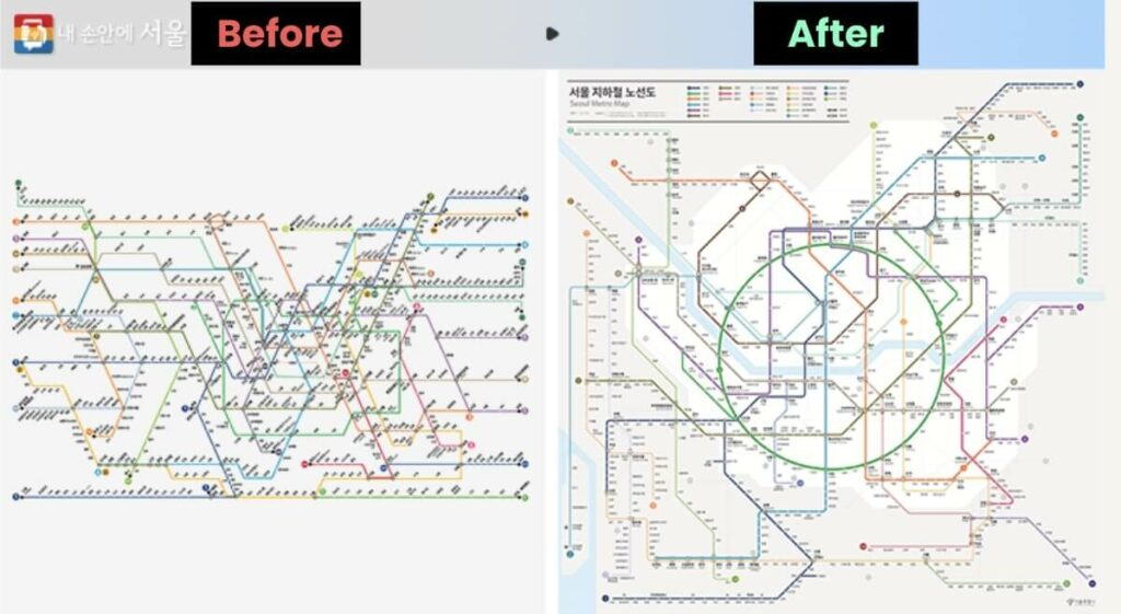
The revised route map will be officially unveiled on September 18 at 2pm at Seoul City Hall. The final design will be announced later this year after collecting opinions from citizens and experts in various fields.
5 Changing Elements of the Seoul Subway Map
1. The newly created route map applies the international standard Octoliner to easily recognize many routes and transfer stations.
2. Transfer stations, which are often identified by the same Taeguk symbol as regular stations, have been replaced with a traffic light system.
3. To make it easier for users to follow their destination, the colors of transit lines are listed and applied in the form of connecting links.
4. Major geographical information such as the boundary between the city center and outlying areas, Incheon International Airport, the sea, and rivers are represented on the route map so that tourists can understand their current location as a bearing.
5. The colors and types of lines (main train, light rail, urban rail, and trunk rail) are classified according to route and importance, and the expression of lines is subdivided through brightness and clarity, focusing on trains 1 to 9.
A Brief History of the Korean Subway
The number of Seoul subway lines has grown from four lines (106 stations) in the 1980s, to nine lines (338 stations) in the 2000s, to 23 lines (624 stations) today.
By 2025, there will be a total of 10 new lines, including the Shinlim Line, Northeast Line, Myeonmok Line, West Line, Uisinsul Extension Line, Mokdong Line, Nangok Line, Wirye Shrine Line, Wirye Line, and the fourth phase extension of Line 9, as well as the Metropolitan Area Rapid Transit (GTX).
However, the route map is still in the form of the 1980s and is mixed in various forms with only routes added, making it difficult to apply additional extension routes.